

jstroede
Well-known member
Ok, here is the case. My wife was wanting to put a screen porch on the back of the house. She hired a surveyor to come out and lay it all out for the city on Friday, and I was not there. It was evident to him right away that it was not going to meet the city setback requirement on the side street. He was really nice about everything and didn't even charge her. He did however mention though that he though there were issues with both my fence as well as my neighbor's fence to the rear. However, the wife did not get a lot of details, and being that we did not pay the guy, I can't really call and ask.
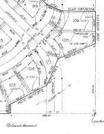
I have been able to locate the subdivision plan from the city. I have lot number 104. I am an engineer but don't know much about civil engineering or surveying. From the two pictures provided, would it be possible or me to locate my property boundries, at least fairly close? Neither my neighbor or myself located our own fences (his fence was there when he bought the house, and I built my fence directly on the existing fence line after a tornado destroyed it.) The neighbor behind me is trying to sell his house, so I would like to figure out if a problem exists.
There is about a 4 ft gap between our fences where the gas and telephone hookups are located, so I don't see how his fence could be that far on my property (my wife thought he said 3'?) with the utilities obviously being in the utility easement. There are plenty of dimensions on the drawing, and some other markings but I am not familiar with them. Are the dots that are dimensioned permanent markers in the ground possibly? The drawing calls out concrete monuments in various parts of the supdivision, but there is no other legend for markings.
If we were in a center lot, I think it would be much harder, but if I can locate the end points of the property on streets, with the lengths shown I can locate the back corner point. Is anyone familiar with these things? I think he told here to come mark everything out would cost about $500, so I really don't want to pay that if I don't have to. Thanks.
John
I have been able to locate the subdivision plan from the city. I have lot number 104. I am an engineer but don't know much about civil engineering or surveying. From the two pictures provided, would it be possible or me to locate my property boundries, at least fairly close? Neither my neighbor or myself located our own fences (his fence was there when he bought the house, and I built my fence directly on the existing fence line after a tornado destroyed it.) The neighbor behind me is trying to sell his house, so I would like to figure out if a problem exists.
There is about a 4 ft gap between our fences where the gas and telephone hookups are located, so I don't see how his fence could be that far on my property (my wife thought he said 3'?) with the utilities obviously being in the utility easement. There are plenty of dimensions on the drawing, and some other markings but I am not familiar with them. Are the dots that are dimensioned permanent markers in the ground possibly? The drawing calls out concrete monuments in various parts of the supdivision, but there is no other legend for markings.
If we were in a center lot, I think it would be much harder, but if I can locate the end points of the property on streets, with the lengths shown I can locate the back corner point. Is anyone familiar with these things? I think he told here to come mark everything out would cost about $500, so I really don't want to pay that if I don't have to. Thanks.
John
Attachments

Last edited: