To avoid these ads, REGISTER NOW!

Buying land without a current survey

Bigblockyeti

Banned
Joined
Feb 1, 2018
Messages
2,550
Location
Upstate, SC
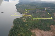
I'm looking at 30 acres in the NC mountains and the survey was done when the mountain was originally subdivided in '04.

Is this recent enough?

I'm planning on contacting the original land surveyor's son who still does the same and would know his dad's practices presumably well regarding markers and at what height.

I'm also planning on contacting the neighbor to see if he's had any issues or had a more recent survey conducted.

My concern is looking at Google earth, the county GIS map and the plat on record, the GIS is slightly off from the other two which look identical and Google earth makes it look like an adjacent camp has a cabin straddling three property lines, that I certainly don't want.

I've walked only part of it as it only has 300' of frontage then gets weird and steep, 30 degrees steep in one area. Many of the lines are between 900' and 1300' so assuming I can easily find many of the 14+ markers might be a bit of a pipe dream. I will lay eyes on all the property markers (and have a current septic permit) before I consider making an offer. In spite of that, I'm still concerned about whether any markers could have been moved.
 
To avoid these ads, REGISTER NOW!

zeke67

Well-known member
Joined
Jun 11, 2010
Messages
272
Location
Houston
I bought a cabin property in 2015 in Minnesota. I had a survey of the neighboring property to the east, from 2000. No survey of the property I bought. I did eventually find two of the property markers to the west 2 years ago. The lender was fine with it, and the buildings were permitted.

All that said, it was pretty clear from both Google Earth views and the county's website (which is ESRI) that there was nothing close to any of the lot lines. If you have conflicting info, at least walk the property looking for stakes, setbacks and so forth. For instance, I can't easily notice where tree branches were cut back for the 200 survey to me east, but my septic installer could where things had trimmed back by looking, and could identify the lot line enough to pull a permit and get it approved.
 

Jlbc212

Well-known member
Joined
Dec 7, 2013
Messages
1,530
Location
Northeast MA
I know in my state we have a "Registry of Deeds." Here if a survey with a description is filed with the Registry it becomes the official record. We also have a land court where any of the records can be challenged. I wouldn't buy a piece of land without a survey, stamped and signed by a state recognized land surveyor or civil engineer and filed and recorded with the "Registry of Deeds."
 

driftpin

Well-known member
Joined
Dec 22, 2016
Messages
11,229
Location
Miami-Dade/Broward Co. Florida
Personally I would never buy a lot or a house etc without getting title insurance. That will almost certainly require a survey.

Current survey, yes. Why would you (b.b.yeti) even think that relying on a stale survey would be a 'good-idea?' You're about to invest a considerable amount of $$$$$. Protect yourself.

Bill's idea of title insurance requires the abstract being examined by a competent attorney, and a current survey. Skimp on neither.

As a former planner in FL, and a licensed plans examiner, the idea of not having a current survey (and no, a 16 year-old survey is not current!) when investing in a real estate transaction, and title insurance is a bad idea.

However, you do what you want.

I used ESRI products daily when I worked as a planner, I have undergraduate and graduate coursework in GIS, and while GIS is helpful in easily researching real property, you need a PSM's product, and the services of a competent real estate attorney writing a title insurance policy to protect your investment.
 

rsparks64

Well-known member
Joined
Mar 22, 2015
Messages
582
Location
Hill Country Texas
Personally I would never buy a lot or a house etc without getting title insurance. That will almost certainly require a survey.

Title insurance does not really cover survey issues. In fact, it does not even cover titles/mortgage recordation very well. In law school, I learned how worthless it can be (except money for title companies) and have had issues twice with my own properties as to property lines. Title insurance is more suited to who may really own the property, but does not guarantee what the property lines are.
 

yeldogt

Well-known member
Joined
Jan 2, 2012
Messages
18,184
It quite common in some states to not need a survey .... have never had new one for any property I bought in PA. Same with needing a lawyer at closing ... state by state.

Just the reverse in NJ .....always a survey and lawyer! NY/CT/MA/VT/SC/FL ... Have bought and sold in all of them ...everybody is a bit different.

In every case -- you are buying the description. The deed description is the property -- title insurance for the deed description. Have never had problems getting title insurance w/o a survey in places where it is not common

In general the properties in PA have been larger -- who cares if my idea if the property is off a few feet.
 

yeldogt

Well-known member
Joined
Jan 2, 2012
Messages
18,184
Title insurance does not really cover survey issues. In fact, it does not even cover titles/mortgage recordation very well. In law school, I learned how worthless it can be (except money for title companies) and have had issues twice with my own properties as to property lines. Title insurance is more suited to who may really own the property, but does not guarantee what the property lines are.

People don't understand ..... I hear you.

I have run into some strange situations ... especially with old properties. Some have parts bought and sold. Long time owners could have had an IRS problem 20 years ago. Odd taxes not paid .... In some states the title company does all the work at closing. In other places ... you pay for a recorder.

Interesting how it is so different .... Thinking now -- I have sold property in NJ w/o a lawyer present .... never bought.
 

LOW1

Well-known member
Joined
Jul 20, 2018
Messages
2,639
Location
ontario
I would consider a 2004 survey as being recent. Walk the property carefully to see if there are any recently constructed fenced paths buildings etc that may encroach upon the property
 

mcbane

Well-known member
Joined
Jul 23, 2017
Messages
794
Location
California
This discussion is amazing to me but I realize law and survey costs vary from state to state. In CA, expect to pay $2k in surveyor fees for a property you might not buy. Your alternative is to spend a bit of time to get a “free” copy parcel map, $1 per page, at the county assessors office and try to find the referenced corner pins on your own. See if that matches your understanding of what you might buy.

For what it’s worth while in college I ran calcs for a surveyor, and have personally verified circa 1970 surveys in the forest. The guys from the 1970s didn’t have gear like you can get today but they weren’t Fred Flintstone either. My current property, 15 acres subdivided in 1973, checks out to section corners ( 1 mile squares set by USGS) within 0.2 ft.


Sent from my iPhone using The Garage Journal mobile app
 
OP
B

Bigblockyeti

Banned
Joined
Feb 1, 2018
Messages
2,550
Location
Upstate, SC
Good info so far, thank you everyone for that. It won't be finaced. Title insurance is something I wouldn't go without, I will also call my closing attorney used for other properties in SC to get their opinon on the benefits of a closing attorney for the property in NC. I knew the survey wasn't by any means recent but I didn't think that 14 years on a still largely undeveloped area could be considered stale. When I contact the son of the man that has his signature on the plat map, I will inquire about the cost, lead time and benefit of performing a new survey.

I really need to find out what markers I need to look for and get boots on the ground to see what I can find.
 

L5wolvesf

Well-known member
Joined
Dec 4, 2011
Messages
1,831
Location
Northern AZ
As part of my work I sometimes have to review a legal description. I always assume the person who wrote it didn't do so and messed it up. I've made come good money doing reviews and correcting them - including ones that were less than 10 years old.

Have a survey done or have expensive problems later.
 

LOW1

Well-known member
Joined
Jul 20, 2018
Messages
2,639
Location
ontario
Do you have a copy of the 2004 survey? That will show how the corners are marked or "pinned." The "pins" the surveyor used are most likely 3 foot long or so pieces of metal pipe or rebar which have a cap containing the surveyors name or license number. If you dont have a copy of the survey you should be able to get a copy from the local office which handles deed recording for your county. The survey will also likely contain the legal description for the tract. If you can decipher this description enough to find one of the pins you can usually go from that pin and locate the others. A very long tape measure and string may be helpful. Also a lite shovel may be helpful to find the pins because they may be flush or slightly under the ground. A metal detector could also be useful. Take some stakes with you to better mark the pins
 

nadogail

Well-known member
Joined
Jan 23, 2009
Messages
31,942
Location
Coronado, CA
All of my Realestate holdings are single family homes in subdivisions in developed cities. Where my home is, I can show you the survey nails and tags in the side walk and alley.
We just go with title insurance
 

cvairwerks

Well-known member
Joined
Aug 12, 2016
Messages
7,210
Location
Within hearing distance of Texas Motor Speedway
Mom and Dad ran into some huge problems with their place about 25 years ago. Official survey had misplaced a single pin by about 5 feet way hack in the 1960’s. Discovered the mistake caused a problem with about 60 lots. City and county gave up after working on fixing it for over 10 years. All the legal descriptions and deeds got amended to “as currently laid out and built upon as of a certain date. Played heck with a bunch of home sales.

Mom and Dad’s driveway has from 1 foot to 5 foot of the backyard on the neighbor’s lot according to the original survey.
 

Fatboy148

Well-known member
Joined
Feb 15, 2017
Messages
999
I knew the survey wasn't by any means recent but I didn't think that 14 years on a still largely undeveloped area could be considered stale. When I contact the son of the man that has his signature on the plat map, I will inquire about the cost, lead time and benefit of performing a new survey.

I would think that you don't need a new survey, you would want the son to do a (re)certification of their work.
 
OP
B

Bigblockyeti

Banned
Joined
Feb 1, 2018
Messages
2,550
Location
Upstate, SC
I would use the GIS as a reference not as a true definition of property lines.

I am, I realize, and they have a disclaimer you have to click on before proceeding stating just that. I do find it odd the plat and Google earth match and the GIS is different. I would think the folks in the county office would want the GIS to be if anything, a better representation of where the actual lines are. Then again, the software they've bought has come from the lowest bidder.
 

NUTTSGT

Super Moderator
Staff member
Joined
Sep 14, 2009
Messages
50,911
Location
Northern Central Ohio
I am, I realize, and they have a disclaimer you have to click on before proceeding stating just that. I do find it odd the plat and Google earth match and the GIS is different. I would think the folks in the county office would want the GIS to be if anything, a better representation of where the actual lines are. Then again, the software they've bought has come from the lowest bidder.

Don't forget the picture comes from a satellite so it can be off from an angle of how the picture was taken.
 

strizzy

Well-known member
Joined
Apr 4, 2006
Messages
572
Location
Western NY
As a PLS in several colonial states, I personally would NOT buy anything unless I was familiar with the property. If the son has taken over his fathers business, redate surveys are typically a fraction of the cost of a new survey. This will also ensure you are aware of any encroachments that may be on your property

I would also recommend a title report run (abstract), typically for closings they are only run 40 years back, I would do double that if I were buying a property. This should be given to the surveyor to review and illustrate any encumbrances or rights to others that be on the property such as easements, mineral/gas rights, etc.

My FIL decided as the wiz realtor he was, he didn't need a survey, now I have a project I didn't need and he placed improvements within a town easement...
 
To avoid these ads, REGISTER NOW!

aka Larry

Well-known member
Joined
May 2, 2012
Messages
8,034
Location
Eastern, NC
My concern is looking at Google earth, the county GIS map and the plat on record, the GIS is slightly off from the other two which look identical and Google earth makes it look like an adjacent camp has a cabin straddling three property lines, that I certainly don't want.

Q: Guess where the county gets the information to input into their GIS system?
A: PLS (Surveyor)

GIS data is meant to be for general reference only. If you are concerned, a title search would be the best way, which will may require an additional ALTA/NSPS survey.
 

gtsgarage

Well-known member
Joined
Oct 31, 2017
Messages
482
Location
California
I don’t think 2004 is stale at all. My proprieties were divided in the ‘70s.

I just did a survey on my primary residence. For a small property in CA it was $5k. Sure enough my property lines are on the neighbors side of the fence on two sides. I’m doing a very expensive backyard renovation and wanted exact measurements. It was worth the cost.

At my cabin which I just bought, I own two lots and walking the boundaries I’ve only found one stake. But that helps a lot as now I can start measuring.using the parcel map. I plan on doing that before the snow falls. The lots are small enough to know I was generally ok.

I wouldn’t go without if I was worried a cabin was encroaching.
 

Northislander

Well-known member
Joined
Dec 7, 2016
Messages
479
Location
Vancouver Island
Bought and sold an acreage in 2004 using the 1948 survey found all but one pin. Bought 146 acres last year surveyed in 2013 did not get a new survey. Picture from realtor attached. Have found all pins using an old school compass tape measure and a hand held gps mated with a program called ozie explorer
 

Attachments

  • lotd aerial.jpg
    lotd aerial.jpg
    148.8 KB · Views: 85

driftpin

Well-known member
Joined
Dec 22, 2016
Messages
11,229
Location
Miami-Dade/Broward Co. Florida
I am, I realize, and they have a disclaimer you have to click on before proceeding stating just that. I do find it odd the plat and Google earth match and the GIS is different. I would think the folks in the county office would want the GIS to be if anything, a better representation of where the actual lines are. Then again, the software they've bought has come from the lowest bidder.

As a PLS in several colonial states, I personally would NOT buy anything unless I was familiar with the property. If the son has taken over his fathers business, redate surveys are typically a fraction of the cost of a new survey. This will also ensure you are aware of any encroachments that may be on your property

I would also recommend a title report run (abstract), typically for closings they are only run 40 years back, I would do double that if I were buying a property. This should be given to the surveyor to review and illustrate any encumbrances or rights to others that be on the property such as easements, mineral/gas rights, etc.

My FIL decided as the wiz realtor he was, he didn't need a survey, now I have a project I didn't need and he placed improvements within a town easement...

Sounds like you're on the correct path to eliminating any potential headaches, and wallet-drains from undiscovered, title issues/liens & etc.

Especially when you're speaking about a 30 acre purchase, there is a lot to possibly 'go-wrong.'

Yes, the parallax-error of GIS maps is something to-be considered, as nuttsgt mentioned. Pictometry is an alternative to GIS https://www.eagleview.com/product/eagleview-reveal/ and it's now eagleview. When I was studying GIS in college, we were exposed to pictometry, though the work we did for projects and testing was all-done with ESRI products.

Looking at things from multiple perspectives often allows you to make a better-informed decision about something. Also, the most-current data is going to allow you to evaluate that which was done-before, assuming that you have access to it, and that's the purpose of the current survey and the abstract. Going with the most-experienced professionals that you can find/afford is a safeguard of your assets.
 

F451

Well-known member
Joined
Jul 18, 2010
Messages
991
Location
WA State, USA
Very timely thread. I'm considering buying one of three rural properties and would like to have the one I make an offer on surveyed. I wouldn't feel confident about the boundaries, possible encroachments, etc, unless I had one done. The properties range from 10 acres waterfront, 70 acres waterfront, 90 acres across the street from waterfront. Each property is only 1 acre wide, so it would be very important to know exactly where the boundaries are.

And all three are inherited/family owned. Yikes, Lol.
 

pcmeiners

Well-known member
Joined
Aug 13, 2009
Messages
7,893
Location
In the only town in Pennsylvania, Bloomsburg.
Pennsylvania does not require a survey for real estate purchases. As to Title insurance (owners, not lenders), it covers you and your heirs from many issues which can arise, and the court costs defending your right to the property. Issues such as an ex-wife, a couple generations back of a previous owner, from claiming rights to your property. Heirs from an estate 80 years ago making claims, municipalities making claims, banks making claims etc. If you want to risk claims/court costs due to your property, by all means skip Title insurance.

As to a survey, property does not move a great deal in a hundred years due to land plate movement so what is the great need for a survey ( especially if you have markers) unless you are building and coming close to a boundary line or if an adjacent owner encroaches the line. Some municipalities require a survey on land sales or building.
 

Zmann

Well-known member
Joined
Feb 24, 2019
Messages
302
Location
Arizona
in the neighborhood I live in some lots are still undeveloped but all were surveyed

two neighbors were in disagreement of a driveway location even with the few years old survey pin found .. one neighbor had that corner surveyed by another company
and it moved the pin a foot over on the other neighbors' lot they also removed the previous survey pin ,, nothing but ugly going on .. funny thing is these same " mean" people encroached onto state land by 40 feet and the state won't do anything

I always wondered what would happen in a survey conflict if it went to court
 

theoldwizard1

Well-known member
Joined
Feb 22, 2011
Messages
43,138
Location
SE MI
Personally I would never buy a lot or a house etc without getting title insurance. That will almost certainly require a survey.

Ttitle insurance companies usually do their own survey, but do not leave permanent markers.

For that much land, I would want permanent markers.
 

theoldwizard1

Well-known member
Joined
Feb 22, 2011
Messages
43,138
Location
SE MI
Title insurance does not really cover survey issues. In fact, it does not even cover titles/mortgage recordation very well. In law school, I learned how worthless it can be (except money for title companies) and have had issues twice with my own properties as to property lines. Title insurance is more suited to who may really own the property, but does not guarantee what the property lines are.

IANAL. Several years ago, one GJ member had a MAJOR title fight with a neighbor regarding a supposed easement. I took several years to resolve. Member had to higher his own attorney because the title company refused to defend him (even though his contract with them said that they would).

In the end, the member prevailed and collected some damages. The title company got slapped with a big fine. The attorney wanted to sue the tilte company for "mental pain and suffering", but they did not go forward with that suit.
 

pcmeiners

Well-known member
Joined
Aug 13, 2009
Messages
7,893
Location
In the only town in Pennsylvania, Bloomsburg.
".. funny thing is these same " mean" people encroached onto state land by 40 feet and the state won't do anything "

In many states you can not get away with squatters rights doing an adverse possession of state or city land. In many areas, even if private property, to claim squatters rights it is very difficult.
 

theoldwizard1

Well-known member
Joined
Feb 22, 2011
Messages
43,138
Location
SE MI
Do you have a copy of the 2004 survey? That will show how the corners are marked or "pinned." The "pins" the surveyor used are most likely 3 foot long or so pieces of metal pipe or rebar which have a cap containing the surveyors name or license number.
Not always !

It depends on who paid for the survey and if it included installing pins.
 

theoldwizard1

Well-known member
Joined
Feb 22, 2011
Messages
43,138
Location
SE MI
Not trying to hijack this thread ...

I have heard (on GJ) of cases where pins were placed 50 (?) years ago, but they do not match up with the current "electronic" equipment.

Who "wins" ?
 
OP
B

Bigblockyeti

Banned
Joined
Feb 1, 2018
Messages
2,550
Location
Upstate, SC
Not always !

It depends on who paid for the survey and if it included installing pins.

I have a digital copy of the plat which for all intents and purpose is the survey as it has the land surveyor's license number and signature on it in addition to a legend identifying all marker locations and type (iron pin). The legend identifies there could be "existing" and "new" iron pins but all that inclose the property I'm interested in are identified as new. The creek bordering the back edge of the property is also laid out in points (not actual pins) which could be an advantage only if 1) I cared and 2) if the creek were to be rerouted for some reason.

The plat (also survey) for another property I have in SC identified one bordering line as "branch and gully the line" which has been explained to me by a real estate lawyer as the property line being in the middle of the creek. There are mechanisms in place to rectify the border should any creek rerouting occur. Given the creek has been there for a very long time and is line now only with stone, it's not going anywhere on it's own.
 

vpd66

Well-known member
Joined
Mar 1, 2010
Messages
709
Location
Central Wisconsin
I learned from experience to make sure the property your buying is surveyed and well marked. I purchased an 11 acre parcel in 2002 that the owner owned for 4 years. No one required a survey so I thought cool that will save some time and money. In the long run it has been a pain in the a** numerous times. I've had a dispute with the neighboring land owner for quite some time. He seems to think he knows where the line and corner marker is but fails to show me. I've looked several times and can't find it. I've looked at Google maps (I know the accuracy is not that good) and I think he is several feet off. So after all this bitterness between us I payed to have it surveyed. Turns out I was correct and he was wrong. Now our lot line is properly marked and no more disputes. Morel of the story, never buy property without it being marked out and know exactly where your lines and corner markers are.
 

rjacobs

Well-known member
Joined
Jul 24, 2015
Messages
3,868
Location
Dallas, TX
Don't forget the picture comes from a satellite so it can be off from an angle of how the picture was taken.

They come from an airplane... not a real satellite picture...

I got buddies that fly for the companies contracted to Google to take pictures for Google Maps "satellite"...

Mostly King Airs. The cameras are supposedly worth about double what the airplane is worth.
 

driftpin

Well-known member
Joined
Dec 22, 2016
Messages
11,229
Location
Miami-Dade/Broward Co. Florida
Not trying to hijack this thread ...

I have heard (on GJ) of cases where pins were placed 50 (?) years ago, but they do not match up with the current "electronic" equipment.

Who "wins" ?

I am not an attorney.

The most-accurate survey, by a preponderance of the evidence.

There was an interesting squatter's rights case in Broward Co. FL, (Ft. Lauderdale/Hollywood) by the Intracoastal Waterway. Evidently while the squatter had been living continuously on the parcel for the statute-mandated time, he had-not been paying the taxes on the property during the time he was in-residence there. If he had, he would have had established his claim under the regulations according to the State of Florida. The parcel was covered with all-sorts of junk, trash, and debris, including old vehicles, non-seaworthy boats of many sizes, discarded and scavenged building materials, etc.

It went to court, and he was evicted from the parcel. The location is a protected wetland. His accumulations of many years-worth of scavenging were removed, and the site was restored to a natural habitat.
 

Attachments

  • Squatter parcel FL.jpg
    Squatter parcel FL.jpg
    20.6 KB · Views: 33
  • Squatter parcel FL.02.jpg
    Squatter parcel FL.02.jpg
    21.4 KB · Views: 30

Leaflessshadetree

Well-known member
Joined
Aug 1, 2013
Messages
7,149
Location
Don't ask.
They come from an airplane... not a real satellite picture...

I got buddies that fly for the companies contracted to Google to take pictures for Google Maps "satellite"...

Mostly King Airs. The cameras are supposedly worth about double what the airplane is worth.

Don't forget the pictures comes from an airplane so can be off from an angle of how the pictures were taken. Many pictures are placed to make a large picture. Then "lines" are overlaid on those pictures. Each step has a poytential to add some error.

When I applied for a variance to build close to one property line the county department showed me their "new" computerized survey map. Said I was easily within the setback. Then commented that 1/2 of my neighbors building was on my property. I pointed out that the county roads, a major railway and several other obvious properties were all off by about 50 FT.
 

driftpin

Well-known member
Joined
Dec 22, 2016
Messages
11,229
Location
Miami-Dade/Broward Co. Florida
Don't forget the pictures comes from an airplane so can be off from an angle of how the pictures were taken. Many pictures are placed to make a large picture. Then "lines" are overlaid on those pictures. Each step has a poytential to add some error.

When I applied for a variance to build close to one property line the county department showed me their "new" computerized survey map. Said I was easily within the setback. Then commented that 1/2 of my neighbors building was on my property. I pointed out that the county roads, a major railway and several other obvious properties were all off by about 50 FT.

Obviously, that person is ignorant of the legitimate uses of GIS and mapping technology. If someone in government told me that, I'd ignore them, and request a determination letter from the Engineering Dep't., the Planning Dep't., or whatever entity in the AHJ is responsible for the plat books and their maintenance. A sealed survey stops arguments.
 

yeldogt

Well-known member
Joined
Jan 2, 2012
Messages
18,184
Not trying to hijack this thread ...

I have heard (on GJ) of cases where pins were placed 50 (?) years ago, but they do not match up with the current "electronic" equipment.

Who "wins" ?

The guy with the accurate survey
 

yeldogt

Well-known member
Joined
Jan 2, 2012
Messages
18,184
I bought property back in the mid 00's -- no survey. There were no issues with the property. No close building -- fences etc. The survey would have given no added value.

Two years ago when I decided to do something with it --- now I need the survey. I paid 7k for the survey .... and it not a huge property. Some places -- they are expensive
 
To avoid these ads, REGISTER NOW!
Top Bottom