To avoid these ads, REGISTER NOW!

Cheapest way to do some topographic surveying? (elevations)

brnctt

Well-known member
Joined
Apr 20, 2023
Messages
107
I'm trying to cut in some ditches, fill in some low spots, and also plan for some drain pipe on 8 acres. The only tool I have right now is a homeowner grade green laser level, which is handy, but i have to wait till dusk and use a 2x4 to see the line, so i only have 1/2 hour or so of working time. I'd like to be able to check an elevation while working in the daytime with my tractor

Any advice on how to measure elevation at various points without investing $600+ in a commercial laser and stick?
 
To avoid these ads, REGISTER NOW!

Firebrick43

Well-known member
Joined
May 12, 2015
Messages
14,152
Location
West central Indiana
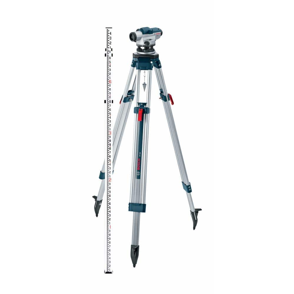
An auto level package and a land wheel

I have a 32x David white that is excellent kit that will last someone who takes care of their tools a life time

A kit including the level, tripod, and grade stick is under 450$.

Any wife or kid can hold the stick for you as long as they hold it vertically.

Land wheel (or tape) to measure distance
 

bbbarracuda

Well-known member
Joined
Jun 1, 2008
Messages
709
Not sure of accuracy, but there are several apps for iphone that show elevation?
 

kmacht

Well-known member
Joined
Apr 12, 2010
Messages
2,773
Location
Connecticut
Nothing wrong with buying a used transit. They still work just as good as new fancy lasers and computers.

If it’s a short enough area a water level made with two sticks and some clear tubing works great as well. I used one to dig and level an area for an above ground pool.
 

tjansson

Well-known member
Joined
Apr 25, 2018
Messages
197
Location
Northern Vermont
I have a Bosch 3 plane laser level and their receiver for it. The receiver works in daylight but has a small receiving range, is too precise, and sometimes it can be really hard to find the line. I only ever used it within a 30 foot radius. I much prefer to just work at dusk and night and use a mark on a stick. My favorite trick is to put your target grade on your shovel or rake handle so it's super quick to stand it straight and see where you are.
 
OP
B

brnctt

Well-known member
Joined
Apr 20, 2023
Messages
107
I also like the idea of setting up a line level with string. I wonder the max distance I can keep the line taught though with the level hanging on it.
 

WisJim

Well-known member
Joined
Dec 20, 2010
Messages
2,292
Location
Menomonie, WI
Not exactly what you are after, but a friend showed me a clever idea for laying out garden/farm beds or terraces to keep them at the same level.
Made an "A" frame of good 2x2s, with a cross brace about half way up. The cross brace is fastened so it is level when the bottom of the "A" is level. Attach a 2ft or longer level on the cross brace. The level will read "level" whenever the 2 bottom feet of the "A" are at the same level, and you can walk this device along a slope and mark off spots that will be level. We used it to mark location of ditches used to slow runoff on a hillside.
 
OP
B

brnctt

Well-known member
Joined
Apr 20, 2023
Messages
107
All the apps I see use barometric readings. Useful for climbing a mountain but not so much trying to measure inches.
 
OP
B

brnctt

Well-known member
Joined
Apr 20, 2023
Messages
107
Not exactly what you are after, but a friend showed me a clever idea for laying out garden/farm beds or terraces to keep them at the same level.
Made an "A" frame of good 2x2s, with a cross brace about half way up. The cross brace is fastened so it is level when the bottom of the "A" is level. Attach a 2ft or longer level on the cross brace. The level will read "level" whenever the 2 bottom feet of the "A" are at the same level, and you can walk this device along a slope and mark off spots that will be level. We used it to mark location of ditches used to slow runoff on a hillside.

Interesting. I've done this a few times but just zip tied a 4ft level to a straight 2x4. Good for short distances as you say! Trying to figure out trenching depth over a few hundred feet though, with my drain pipe as the datum.
 

Rusty Wrench

Well-known member
Joined
Aug 19, 2021
Messages
190
I can understand reluctance to buy. But it sounds like you have a fair amount of grading to do.
Maybe try this: set your ditch or pipe stakes at 50' intervals. Rent an auto or laser level (they're not the same) for a day and put elevations on the top of stakes. The stakes are on an offset that you place your spirit level on top and measure down to grade. With grade stakes in you can work at your leisure.

For the price of that Amazon gizmo I think the accuracy will be on the order of the little Bosch unit- 5/16" in 30'. Not great.
If you really have a lot of grading work I would reconsider Firebricks advice. Then sell it.

Edit to say my neighbor did about 250' of drain with a 4' spirit level. When I checked it for him I found his accuracy was very good.
 
To avoid these ads, REGISTER NOW!

purplezr2

Well-known member
Joined
Jun 1, 2010
Messages
5,299
Location
Central MN
I used my indoor laser level at dusk to mark my elevations for my shed in relation to my house and my driveway.

I was close all the way around when the contract showed up.

Did the same when I redid my septic to get my slope right.
 

rancherbill

Well-known member
Joined
Oct 18, 2007
Messages
5,335
Location
Foothills County, Alberta, Canada
The county does there road and ditch site work with these. It is all you need for what you are doing.

You make your self a stick and start marking down the numbers. Your stick is a known height and you look at the marker stick and you can tell whether you are up or down. I did a bunch of tuff this way. My stick was 4' high and the base marker was a 10' stick with line every 4". Four inches is good enough for ditches.

blog-hand-levels-A1[1].jpg

https://www.google.com/search?q=hand+sight+level&sca_esv=20512a2fd83683ee&rlz=1C1CHBF_enCA950CA950&sxsrf=ACQVn089_DPH1AMViV4gHAp7lXC7rn8qOA:1707881381034&ei=pTPMZYLZAcy_p84PxZ-kkAY&ved=0ahUKEwjCv6P48amEAxXM38kDHcUPCWIQ4dUDCBA&oq=hand+sight+level&gs_lp=Egxnd3Mtd2l6LXNlcnAiEGhhbmQgc2lnaHQgbGV2ZWwyBRAAGIAEMggQABgIGAcYHjIGEAAYHhgPMggQABgFGAcYHjIGEAAYCBgeMgYQABgIGB4yBhAAGAgYHjIGEAAYCBgeMgYQABgIGB4yBhAAGAgYHkjzPlCLCliBJ3ABeAGQAQCYAcoBoAGDDKoBBTAuOC4xuAEMyAEA-AEBwgIKEAAYRxjWBBiwA8ICCBAAGAcYHhgPwgILEAAYgAQYigUYhgPCAgoQABgIGAcYHhgPwgIGEAAYBxgewgIIEAAYBxgeGArCAgsQABgHGB4YDxjHA-IDBBgAIEGIBgGQBgg&sclient=gws-wiz-serp
 

rayra

Well-known member
Joined
Dec 1, 2014
Messages
4,724
Location
Escaped from Los Angeles
I'm trying to cut in some ditches, fill in some low spots, and also plan for some drain pipe on 8 acres. The only tool I have right now is a homeowner grade green laser level, which is handy, but i have to wait till dusk and use a 2x4 to see the line, so i only have 1/2 hour or so of working time. I'd like to be able to check an elevation while working in the daytime with my tractor

Any advice on how to measure elevation at various points without investing $600+ in a commercial laser and stick?
most towns with 40-50k people should have an equipment yard where you can rent that laser rig.
But also relatively easy to do with a 100' garden hose for a water level and some T-stakes

Home Depot has a Bosch kit for half your expected price
 

pembol

Well-known member
Joined
Feb 13, 2014
Messages
274
With professional surveyors moving towards robotic total stations and differential GPS, older total stations, transits and auto levels are really cheap on ebay. I bought a 'non working' Sokkia total station (needed a new battery for $12) on ebay for $200, and have used that to layout our landscaping, it does take two people to use and has a learning curve, but gets you elevation and distances in one go. If you just want elevations, there are a ton of auto levels for < $100.

This is not the simplest route, but good fun if you enjoy some recreational geometry.
 

LopezBart

Well-known member
Joined
Oct 13, 2023
Messages
2,561
Location
Lopez Island, WA
I've done this sort of thing with a water level; the big advantage is that it works around corners, through trees, etc. It's best used w/ two people, and the cost is pretty reasonable - two yardsticks and a pile of plastic tubing. However, between clearing our shop site, grading the patio area (another project awaiting more time) and resolving drainage issues on my parent's estate, we decided a laser setup was worthwhile. About $400 from Amazon three years ago - gack, now nearly $600.

You might also check into the laser level detectors; this is what is on the stick on the fancy laser units. I'd definitely double check the accuracy of your green laser level when using this approach (measure height between two points in both directions for example), but if it's good enough for your project that might be a cheaper solution that makes it easy to work by yourself. The detectors will sense laser light I cannot see at all.
 

bb29510

Well-known member
Joined
Dec 27, 2022
Messages
1,216
i wish i could fnd me an older transit. I already own a david white level
 

ycgoat

Well-known member
Joined
Mar 28, 2020
Messages
971
Location
S.E. Va
I have been looking for something along these lines too and a way to transfer that info into Autocad along with Arial and building plans.

3 transits just sold the other day on Public surplus, being sold from my employer. I bid on some until they went above $500. I did not look to see what the final sale price was.
 

pima67

Well-known member
Joined
Dec 5, 2009
Messages
308
Location
Tucson, AZ
Look for an Abney level -- price ranges from $100 to $200. More expensive ones allow setting it for the desired grade. I used to locate logging roads using one. Max grade of 6% but short runs of 8% OK in some instances.
 

Milton Shaw

Well-known member
Joined
Feb 11, 2011
Messages
4,845
I have a water level that has a bucket on one end and just sight glass on the other end. The bucket top is at least 1000 times the sight glass surface area so the bucket stays the same and the sight glass levels with just one person, no need to watch the bucket level. I have laser level, builders level and a total station but the bucket water level is the only one person needed to level
 

LopezBart

Well-known member
Joined
Oct 13, 2023
Messages
2,561
Location
Lopez Island, WA
but the bucket water level is the only one person needed to level
With the laser, I set up the rotating laser gizmo and then walk around w/ the stick, raising and lowering the detector until the light on the detector is green. It's nice to have someone there to make notes as I call out heights, but the same is true for a bucket water level, I'm sure.
 
To avoid these ads, REGISTER NOW!
Top Bottom