To avoid these ads, REGISTER NOW!

Land Survey

2mJps

Well-known member
Joined
Feb 20, 2012
Messages
1,797
Location
north central Mo
Can some help me understand how to read a Survey. I am trying to figure out some land that was sold years ago. I have the survey from back then the fences were to be the property lines. Its just under 5 acres it has a road on one side and a creek on another. How close is google earth? I measured it with that and came up with something different but i measured buildings and they came out ok. This could be a problem some day and if it that happens i with spend the money and have it surveyed. I also got a aerial map from the courthouse that shows the properties fences are the lines how accurate is that?
 
To avoid these ads, REGISTER NOW!

Captain Spaulding

Well-known member
Joined
Feb 13, 2017
Messages
749
Location
Southern Indiana
Pretty straightforward. Should be dimensions and directions for all boundaries. For angles that aren’t square, make the area into a rectangle and triangle to figure the area of each. Be sure you understand where on the road and creek the line lies. Often on county roads, the property line is in the center. Same for creeks and ditches. Major roads often have a right of way a certain distance from the center line. Rules are different in different states.
 

woodscaper

Well-known member
Joined
Aug 18, 2013
Messages
105
Location
central pa
You may be able to go to your county's web site and look up the GIS mapping parcel viewer, a lot of municipalities have this now. Generally they have the ability to display info about the property and have measuring tools that are real close. Sometimes the lines are a bit off as you can see the property lines don't necessarily line up with what you know is correct.
 

BillK

Well-known member
Joined
Aug 24, 2006
Messages
9,312
Location
Beautiful Southern Maryland
I have the survey from back then . . . . . .
If the surveyor is local and still in business ask them how much they would charge to come back out and find the corner marks. To me it would be well worth paying for the peace of mind. No way I would trust Google maps or Earth for something that important.
 
OP
2

2mJps

Well-known member
Joined
Feb 20, 2012
Messages
1,797
Location
north central Mo
If the surveyor is local and still in business ask them how much they would charge to come back out and find the corner marks. To me it would be well worth paying for the peace of mind. No way I would trust Google maps or Earth for something that important.
That was in 1979 they are no longer around. There is one surveyor in about 50 mile radius i talked to them and they said they would but they are 6 months behind. If it got to be a deal i may talk to them with cash in hand to see if i could get it done. I dont trust the maps but they do show what i believe to be right.
 

LOW1

Well-known member
Joined
Jul 20, 2018
Messages
2,635
Location
ontario
Can some help me understand how to read a Survey. I am trying to figure out some land that was sold years ago. I have the survey from back then the fences were to be the property lines. Its just under 5 acres it has a road on one side and a creek on another. How close is google earth? I measured it with that and came up with something different but i measured buildings and they came out ok. This could be a problem some day and if it that happens i with spend the money and have it surveyed. I also got a aerial map from the courthouse that shows the properties fences are the lines how accurate is that?
Does it have what is called a “metes and bounds“ description? Something like “N 47 degrees 15 minutes East 225 feet and 4.10 inches, thence North 175 degrees 31 minutes East 140 feet . . .?

To decipher these you use an old fashioned junior high school half circle protractor. It’s like charting a course on a boat. Each portion of the description which is separated by a comma or a semicolon describes one section of the property boundary. At each such change of angle the surveyor should put a “pin” which is usually a two or three foot long piece of rerod or iron pipe pounded in the ground.

For angles which start with “north” put the rounded edge of the protractor up with zero pointing to the North. East is to the right so for the above description approximate a mark which is 47 degrees angled down and to your right and which is 225 feet and 4 inches long. Don’t worry about the smaller minutes and even smaller seconds which are subdivisions of minutes. For descriptions which start with “south” point the protractor down .

The legal should have a “point of beginning” which is the start of the first “leg” of the description.

The survey map or “plat of survey” will usually show the surveyors pins as small circles. Open circles are old pins. New pins are solid circles.

Good luck!
 

spudley

Well-known member
Joined
Dec 27, 2016
Messages
702
Location
Northeast Wisconsin
Did the 1979 survey put in corner marks, usually 1" or 2" pipe? I found my corners were marked years ago on the county GIS map so they were easily found with a metal detector.
 

quickfarms

Well-known member
Joined
Feb 14, 2021
Messages
1,027
Location
Southern California
Surveyors use one hundredth of a foot

one hundredth of a foot is approximately 1/8”

so one tenth of a foot, 0.1’, is approximately 1.25”

the aerial photos shown on either google earth or any GIS database are not very accurate and the line work in the GIS database is questionable because it is typically not created by a surveyor

the accuracy of an aerial photograph is plus or minus 1/2 a contour interval. I typically have sites flown a 1’ contour interval. The problem with this is the area being covered in each photo is to small to be efficient for mapping an entire city or county bur is perfect for mapping a commercial site. Typically large areas are mapped at a 10’ or 20’ contour interval. The other problem is that the aerial photos may not even be scaled, this is when they are tied to actual surveyed targets and scaled to fit the targets.

this is an example of an aerial target
 

Attachments

  • 6662CDB1-C8B0-4F91-BA0B-34483BD21EA3.jpeg
    6662CDB1-C8B0-4F91-BA0B-34483BD21EA3.jpeg
    633.8 KB · Views: 48
OP
2

2mJps

Well-known member
Joined
Feb 20, 2012
Messages
1,797
Location
north central Mo
We have a tape measure 200 feet? or bigger i may try to measure it. I know it will not be perfect but it may get me close.
 
  • Like
Reactions: 555

Worsedog

Well-known member
Joined
Mar 2, 2008
Messages
1,509
Location
Central FL
You may be able to go to your county's web site and look up the GIS mapping parcel viewer, a lot of municipalities have this now. Generally they have the ability to display info about the property and have measuring tools that are real close. Sometimes the lines are a bit off as you can see the property lines don't necessarily line up with what you know is correct.
Not sure about the OP's county, but our GIS information has a disclaimer that it is not to be used for boundary disputes.
 

FredWanaker

Well-known member
Joined
Mar 27, 2021
Messages
1,470
Location
NorCal
you can't use Google Earth to map your property other than to give you a general view. You must locate the points on the Earth based on known locations. If your survey is lot, book and tract, or known distance and angles from set points, you need to locate those points compared to the known points. If the survey is Metes and Bounds then you need the Marker points in that map. Examples below:

Metes and Bounds - oldest form. The deed will say something like 210' NW from Farmer Browns old oak tree to the rock at the intersection of Smith and Brown's fields, to the creek, then to the old bluff then back to the beginning point. Without those markers you will have trouble finding the boundaries.

Lot, Book and tract. There will be a survey map of the Land Tract filed in the County offices. Normally there are brass markers on some of the street intersections that you measure from.

Based off Township and section. There will be a marker for your area - typically a mountain top or something like that many miles away a surveyor can see. Then they will use instruments to measure the exact angle in the map to that known point, or another that is known to come off that Baseline and Meridian. Then off that you measure the angle and distance to the next corner. Normally when the property is surveyed the Surveyor marks the corners with a peg, (steel rod in the country is most common). If you borrow a metal detector you may be able to find the rods. Sometimes they will drive a stake in NEAR the rod or peg. The stake you see on construction sites is NEAR the peg but is not the peg.

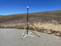
Modern GPS equipment that Surveyor's use is close but not totally accurate. They usually use it to get them very close to where the peg is. Sometimes, depending on the area there can be local GPS senders that are EXTREMELY accurate. In that case the device they are holding is EXTREMELY accurate because it is going off a couple nearby GPS senders that have been surveyed to be perfectly accurate, instead of satellites. Only the military gets the exact location off satellites. The survey company whose equipment I support has GPS devices on their roof top that they use when surveying locally. These have the accuracy the same as like measuring angles to a known mountain top.

All that said, from your map I would borrow a metal detector and look for the steel rods driven in the corners. If they are gone or someone has monkeyed with them, they you will need to pay for a new survey. Sometimes people just do that anyway because it is not totally unknown that someone has moved them to get more land. Some states have laws that after so many years the position of the moved stakes become the new boundaries. Likewise in some states if you have Metes and Bounds, and a creek moves then that can change the size of the lot.

In some states the Title Company / Escrow Officer walks you along the boundaries when you buy the property and you tie a ribbon or drive a stake every so often to prove they walked you along the boundaries. That can take all day on a large lot. I know this because I worked for years in the Mortgage industry all over the country for years, and it can be different between states. In many states a survey is required every 5 years to do anything with the property - sell, or refinance etc., so you might want to start looking now for a survey company if you plan on doing either and your state requires it. In those states if the rods/pegs are missing then they have to re-survey the whole property rather than just confirm the presence of the rods/stakes from the last survey. Good luck.
 
Last edited:

HoosierMark

Well-known member
Joined
Jan 31, 2013
Messages
1,440
Location
Southeast IN
You need to remember when measuring buildings on the computer you have a locked in starting point. You also have the edge of the building to follow. That helps immensely to insure accuracy. When measuring land, unless you can see a fixed starting point such as pin, concrete post or something listed in the legal description you are only guessing at the exact starting point the surveyor used. Also getting the angles correct, can be a real challenge. If you have access to a metal detector and the survey states that pins were placed, you may be able to find one or two of them to work from. In my area, surveyors will locate pins fairly cheaply. Sometimes they can find them at the site and sometimes they need to work from a nearby survey as a starting point. You may want to go to the courthouse and see if any properties around you have surveys on file and then talk to those owners for a starting point to help you search for one of your pins.
 

bassbone52

Well-known member
Joined
Jan 7, 2011
Messages
509
Location
Central Indiana
Can some help me understand how to read a Survey. I am trying to figure out some land that was sold years ago. I have the survey from back then the fences were to be the property lines. Its just under 5 acres it has a road on one side and a creek on another. How close is google earth? I measured it with that and came up with something different but i measured buildings and they came out ok. This could be a problem some day and if it that happens i with spend the money and have it surveyed. I also got a aerial map from the courthouse that shows the properties fences are the lines how accurate is that?
The important factor in this case is what is stated in the land description in the deed. If it contains a phrase “to a fence”, then the fence controls, regardless of distance. Intent is everything. Can’t really comment further without seeing the land description and the survey itself.
 

jkuro

Well-known member
Joined
Apr 28, 2009
Messages
552
As said, go to your local township, city or county and get a copy of the Plot Plan for the parcel in question. They may change a few dollars for this service. Now you have all the information you need.
 

driftpin

Well-known member
Joined
Dec 22, 2016
Messages
11,206
Location
Miami-Dade/Broward Co. Florida
I am not a PSM (professional surveyor and mapper), however, I have multiple surveyors in the extended family. I worked as a planner, and used surveys daily to complete my work.

As others mentioned, no usual GIS map found online is going to be capable of serving as a legal document to delineate property boundaries. If you go to your county engineering dept., and look at the plat maps, that will have the information you can use to determine where things are. A recent survey is what is the proof of boundaries, and what you need to determine things like measurements for layout, setbacks, and other work requiring precise measurements. The plat map will show individual plots, their boundaries, rights-of-way, easements, iron pins (F.I.P.=found iron pin), monument markers, and similar.
 
Last edited:
To avoid these ads, REGISTER NOW!

CraigStu

Well-known member
Joined
May 22, 2014
Messages
4,017
Location
Blacksburg, Va
I have a gps app on my phone. I use that to find my property lines from the GIS map. As I move the mouse curser around on the map it is constantly displaying Lat/Lon so I note some of those and then go for a walk. I find it is accurate enough to get an idea of which tree to tie some hot pink ribbon to which is fine for the wooded portion of our 5 acres. I don't think I would want to build a fence using the gps though. Fortunately, near the house we have pipe driven into the ground for the corners.
 
OP
2

2mJps

Well-known member
Joined
Feb 20, 2012
Messages
1,797
Location
north central Mo
Thanks every one. My main deal is the guy that bought this place in 1979 rented the rest of the land i have papers to prove he paid rent and built a corral on the south west corner of his fence line on our property in the 90s. He sold this place this year and i want the corral gone to avoid any problems with the new owners.The previous owner said they didnt think the west fence was in right place this was after they sold it. I want to try and see if i can measure the south fence line to see if the blue line is the property line it fallows the original fenceIMG_20211127_085549.jpg. I havent talked to the new owners yet about it. In this county the line starts in the center of the road.
 

driftpin

Well-known member
Joined
Dec 22, 2016
Messages
11,206
Location
Miami-Dade/Broward Co. Florida
Any old sealed survey you have is more-accurate than anything GIS you download for free. Look in the abstract record for the parcel, you may find a copy of a sealed survey. As a copy, it won't be an original sealed survey, but you can scale it up to make it easier to read.

There is another type of pictures used for mapping, called Pictometry, developed at the Rochester Institute of Technology.
 
Last edited:
  • Like
Reactions: 555

FredWanaker

Well-known member
Joined
Mar 27, 2021
Messages
1,470
Location
NorCal
"and built a corral on the south west corner of his fence line on our property in the 90s."

Personally I'd get a survey of that lot line, and ask the new owners what the seller represented the sold property to be. You can look at the listing at the selling realtor too to see what the seller represented that corral to be. If the seller and agent showed the whole corral as part of the property for sale, the new buyer may already have plans for it, and in their minds you will be damaging their property. On the other hand if you introduce yourself, have them show you where they were told the lot line is, then you may find it easy to just take it down, or maybe rent it to them too like the last owner. I recently built a fence between two neighbors to help them out since the old one had rotted, The marker was gone so I paid my friend who is a surveyor to mark it again. The reason being that I didn't want someone blaming me for putting a fence in the wrong place. Both owners acted like, no we don't really need to know where the lot line it, we can guess - but when that corner post was put in, both were like hawks watching a meal making sure it was right on the spot. People on both sides of a line care about these kinds of things. Bets are that your neighbors will be just as concerned about getting this right as you are, and they may already have a recent survey showing where the line is.
 

nvrenufrm

Well-known member
Joined
Dec 20, 2010
Messages
88
Location
Grays Harbor County, Wa
I recently bought 5+ acres, it had salal, scotch bloom, blackberries, etc. on it, so for me it was worth it to bring out a surveyor who did actually find the steel rods that identified the property corners.
It cost me $1500, worth it to me for piece of mind (avoiding any future boundry disputes).
 

BillK

Well-known member
Joined
Aug 24, 2006
Messages
9,312
Location
Beautiful Southern Maryland
He sold this place this year . I havent talked to the new owners yet about it. In this county the line starts in the center of the road.
When he sold it did the buyers get a survey ?? Around here it is pretty much mandatory with every property sale. Have you looked for any evidence of new markers etc ? Have you met the buyers ? Maybe they will let you see the current survey ?
 
OP
2

2mJps

Well-known member
Joined
Feb 20, 2012
Messages
1,797
Location
north central Mo
Can you post the survey you have
I can but i need to look it over i dont the location given out.
"and built a corral on the south west corner of his fence line on our property in the 90s."

Personally I'd get a survey of that lot line, and ask the new owners what the seller represented the sold property to be. You can look at the listing at the selling realtor too to see what the seller represented that corral to be. If the seller and agent showed the whole corral as part of the property for sale, the new buyer may already have plans for it, and in their minds you will be damaging their property. On the other hand if you introduce yourself, have them show you where they were told the lot line is, then you may find it easy to just take it down, or maybe rent it to them too like the last owner. I recently built a fence between two neighbors to help them out since the old one had rotted, The marker was gone so I paid my friend who is a surveyor to mark it again. The reason being that I didn't want someone blaming me for putting a fence in the wrong place. Both owners acted like, no we don't really need to know where the lot line it, we can guess - but when that corner post was put in, both were like hawks watching a meal making sure it was right on the spot. People on both sides of a line care about these kinds of things. Bets are that your neighbors will be just as concerned about getting this right as you are, and they may already have a recent survey showing where the line is.
The picture on the listing shows a view of the place including the corral and the pond. I should have went and talked to the new owners first but i started taking down the fence and cleaning up trash and brush with my skidsteer they were out side i would have thought they would have said something to me. I went to the old owners to see if they wanted any of the feeders that they left on our property thats when i found out about them thinking the corral was theirs. I dont want to rent it because i want to clean up the farm and i dont need cows to work around. There are several reasons that i think the corral is not part of that place . Number 1 this was my dads place and he told me that he should have given them the pond because the fence property line was going to cut it in half. 2 why did he wait to build a fence several years after he bought the place. 3 He built a pipe fence were the old fence was but didnt include the corral if i was fencing my place i would fence it all and not leave out a part of it. 4 we cut some logs of the farm 5years ago the logger had the deal on his phone showing property lines and he said the corral belonged to us and the old fence line was in the right place. I think the fence could be off by maybe 10 feet in to the corral but not the hole corral. I am going to measure it and try to find the pin then if i have to i will go and see what it takes to get the surveyor out . Its not a big chunk of land but and if i have to i will rebuild the fence.
 
OP
2

2mJps

Well-known member
Joined
Feb 20, 2012
Messages
1,797
Location
north central Mo
When he sold it did the buyers get a survey ?? Around here it is pretty much mandatory with every property sale. Have you looked for any evidence of new markers etc ? Have you met the buyers ? Maybe they will let you see the current survey ?
No survey it makes me think the old owners are financing it. I brought this up to the old owners and they said they didnt want to spend the money. If it was resurveyed i think i could see it at the court house. I havent talked to the new owners because i didnt want to stir up a fire and make it harder to put out.
 

FredWanaker

Well-known member
Joined
Mar 27, 2021
Messages
1,470
Location
NorCal
"There are several reasons that i think the corral is not part of that place."

Ok - now it is clear what is going on here - best to get a survey because using the "a family member told me, and someone agreed with that" argument won't work in court. The fact they think it is theirs, and the listing showed it, is proof already that without a survey everyone involved has a risk here, or they would in most states I worked in the mortgage industry in. Ohio is the closest in distance to Missouri that I worked in. If they are financing it, in some states the lenders require a title policy that lists the survey, and it becomes part of the policy. You might at this point be able to just get with your neighbor, and split the cost of a survey on that lot line to make the situation as less painful to all as possible. Sharing a pond itself can be an issue because in many places the source of the water determines who has rights and where. A pond that is fed by a creek that crosses many farms for example. Or you can just state what you believe to be yours, tear the corral down and let them pay for a survey. If you are right the burden is on them for not checking their lot lines first. If you are wrong you will be rebuilding a corral I think. There is also that common pond. Depending what the source of the water is ... .
 
Last edited:

lazyriverrat

Well-known member
Joined
Mar 16, 2015
Messages
54
Location
Nebraska
Use your survey and try to locate the pins set by the first surveyor. There are locators for finding these. Depending on how big a city you live in the city workers may have a locator you could use. Look for witness markers left by the surveyor.
 

mikedodge

Well-known member
Joined
Jun 27, 2017
Messages
2,766
If there's going to be any sort of dispute with the neighbors get a proper survey done but It would be worth it to find the pins first. Did the neighbors have a survey done when they bought?
When I bought my land I was given a photocopy of part of a survey by the last owner. I gave a copy to my lawyer and when I went back to sign everything she had a copy of the full drawing that the portion I had came from along with a second drawing that showed boundary lines of every property in the same concession.
 

driftpin

Well-known member
Joined
Dec 22, 2016
Messages
11,206
Location
Miami-Dade/Broward Co. Florida
If there's going to be any sort of dispute with the neighbors get a proper survey done but It would be worth it to find the pins first. Did the neighbors have a survey done when they bought?
When I bought my land I was given a photocopy of part of a survey by the last owner. I gave a copy to my lawyer and when I went back to sign everything she had a copy of the full drawing that the portion I had came from along with a second drawing that showed boundary lines of every property in the same concession.
That's what the county plat map will show you, except you can get a 24" X 36" copy. Assuming it's been platted. Even if it hasn't, the county should have a map showing the parcel on it, and you can order it in the same format it was originally made-in, which is usually 24" X 36." If there is any issue with neighbors over property lines, then you have to call-in a surveyor.

We had the next-door neighbor start excavating for a CBS wall, as part of a $1 million+ SFR re-build, and they were excavating on our property. I tried to speak with the excavator, to show him on a sealed survey where he was encroaching, and he essentially told me, "tough ****."

My next call was to the Building Dept, and the complaint was "scope of work beyond permitted plans, encroaching onto neighboring property," a building inspector showed-up in a half-hour, and he red-tagged the entire job (all trades to evacuate immediately, all-work stoppage). The RPO was pissed, she was acting as owner-builder, but she hired a belligerent excavation contractor who either didn't know his job, or was intentionally encroaching.

A competent surveyor ends the B.S.
 

quickfarms

Well-known member
Joined
Feb 14, 2021
Messages
1,027
Location
Southern California
Technically only a land surveyor can legally expose survey monuments in most jurisdictions. The problem is that lay people often disturb the monument or destroy the evidence of what was there. Depending on the records and what we observe the excavation can be an archeological excavation. everything imaginable has been used as a survey monument over the years and after doing this for almost 5 decades nothing surprises me. I have found the stump of an oak tree called out on a 1792 deed. The remains of wooden 2x2’s. I found a lot of drill rod in one area.
 

bassbone52

Well-known member
Joined
Jan 7, 2011
Messages
509
Location
Central Indiana
The problem is that lay people often disturb the monument or destroy the evidence of what was there.
When we first started using survey-grade GPS in the mid 90's, we had to locate USGS traverse stations for establishing coordinates. Since many of those were set back in the 1930's, they were not easily located. After searching for a couple of hours for a monument we desperately needed, a farmer approached and said it was in back of his barn. Sure enough it was there - propped up against back wall of his barn.
 

quickfarms

Well-known member
Joined
Feb 14, 2021
Messages
1,027
Location
Southern California
When we first started using survey-grade GPS in the mid 90's, we had to locate USGS traverse stations for establishing coordinates. Since many of those were set back in the 1930's, they were not easily located. After searching for a couple of hours for a monument we desperately needed, a farmer approached and said it was in back of his barn. Sure enough it was there - propped up against back wall of his barn.
Around here monuments are being destroyed at an alarming rate by city staff and the contractors that they hire. The funny thing is if they destroy it they say they are not a surveyor and therefore not responsible but if a private company did it they would go after them. The city engineer acts like it’s not there responsibility but the law was changed so it is now there responsibility. Handicap ramps destroyed a lot of tie points. Grinding streets have also destroyed a lot of monuments, in certain cities all we find is the bent spike or its shank down a few inches
 
Last edited:

PoorUB

Well-known member
Joined
Mar 29, 2021
Messages
11,622
Location
Fargo, ND
Get your property surveyed, who cares about the ajoining land, get yours done! Trust me, it will be worth it instead of not worrying about it until someday when the **** hits the fan. Make sure the surveyor puts in easily located pins. When I bought my place I asked my neighbor and we found all the pins.

Good surveys make good neighbors!
 

csp

Well-known member
Joined
Mar 23, 2010
Messages
5,719
Location
Franktown, CO
Around here monuments are being destroyed at an alarming rate by city staff and contractors. Handicap ramps destroyed a lot of tie points. Grinding streets have also destroyed a lot of monuments, in certain cities all we find is the bent spike or its shank down a few inches
I worked for a land surveying company during the summers when I was in college. One year we were looking for a USGS brass cap that was supposed to be in a hillside next to a highway that had a planned widening, but never found it.

The next summer they began widening that highway and my dad had a load of sand delivered for a paver patio he was installing from the excavation contractor who was working on that job and we found the marker in the pile of sand on his driveway that we were looking for the prior year. The area it was excavated from was probably 300 yards from where it was supposed to be, so someone must have dug it up, including the concrete it was buried in and moved it.

The company I worked for installed property pins made of #4 rebar with aluminum caps cast with the company name and registered land surveyor number so that future surveyors could access our records if needed.
 
To avoid these ads, REGISTER NOW!
Top Bottom