To avoid these ads, REGISTER NOW!

What is north on a plat?

vavet

Well-known member
Joined
Mar 6, 2012
Messages
5,325
Location
Ashland, VA
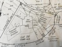
I'm trying to figure out where my new garage will be built, but I have to be conscious of the property line and setbacks. I have the plat. It makes sense to me that north on the plat should be TRUE north, not magnetic north. Magnetic north changes over time, so that could change things.

Also...I've learned the compass on my iPhone 5s is neither precise nor accurate.

I'm leaning towards the belief that my cheap big box store compass is more accurate but still about 5 degrees off, but at least I can work with it if it is consistently 5 degrees off in the same direction.
 

Attachments

  • IMG_0142.jpg
    IMG_0142.jpg
    140.6 KB · Views: 247
To avoid these ads, REGISTER NOW!

Radix2

Well-known member
Joined
May 28, 2014
Messages
1,853
Location
the thumb!, MI
I'd find your corner markers and work off tapes and strings. Or at min use them to answer your compass offset question.
 
OP
V

vavet

Well-known member
Joined
Mar 6, 2012
Messages
5,325
Location
Ashland, VA
Work off of known points. The compass isn't really going to help.

That's the problem. I have only one corner that I can find - the one in the SE corner. I'm trying to find the SW corner. I can find the point 81 feet from that point along the rear property line because it will be collinear with my neighbor's rear fence line. Then it jogs to the south. I want to know where that line is.
 

1973AD

Active member
Joined
Apr 23, 2013
Messages
35
Since there are bearings and distances, N ** ** ** W, **.**', it appears as though those are the dimensions of the parcel. Surveyors use the N ** ** ** W designations(bearing) and they are based on the known bearing of some existing, retraceable, line. That retraceable line is know (in my neck of the woods) as the "basis of bearing". So the bearing of the lines on that map are relative to some other, existing and known, line near your property, not true or magnetic north. I'm used to seeing section lines used as the basis of bearing, but I live in an area that is mostly split up into a north/south/east/west grid. Logical but boring.

If it were me I would search for any set corners. If you have a full size copy of that map look for a legend to see what the little circles mean. It might say "set 1/2" rebar" or something like that.
 

ddawg16

Well-known member
Joined
Jul 11, 2008
Messages
21,005
Location
S. California
Just be aware....ground moves....

It's a real problem here in California.

I paid to have my property surveyed a few years ago when I was doing my garage....glad I did...I gained 6" on one side....as compared to old pins......doesn't sound like much....but....when there is a big *** tree in the neighbors yard within 2" of that new line....it didn't take much to convince him the tree needed to go...I paid for the removal....but there were no hard feelings.....

Neighbor behind me was even happier....about half the leaves from that tree fell in his yard....the other half in mine....
 

Firebrick43

Well-known member
Joined
May 12, 2015
Messages
14,088
Location
West central Indiana
Surveys can be really funky sometimes. Until recently they used chain and rods, land wheels, and transits off a known established point (exsisting survey pin) and it may (or may not be accurate). The don't work off magnetic north. Metal detector is more useful than a compass.

Be careful about using GPS. Many times the known point is set off another known point and so on. Errors creep in and when you find the coordinates using sub inch waas corrected GPS points can be 20' off or more from the original pins. Historical property line trump the GPS lines. If it has been down recently it may have done with GPS
 
OP
V

vavet

Well-known member
Joined
Mar 6, 2012
Messages
5,325
Location
Ashland, VA
Between the two septic fields and the wetlands, I'm wondering where you are thinking of building.....

This is the initial plat but the house and septic fields are not where they are pictured here. This was the first draft I rejected because I knew the garage was going to be built. The SE corner of the house is about 30 feet from the property line and it is rotated to face north at that place. The primary septic is pushed farther towards the street and reshaped. The secondary septic shifted NW next to the driveway. The garage will go in the SW corner.
 

73RR

Blank Email
Joined
Dec 13, 2016
Messages
300
Location
Central Ory-Gun
If you do not have a current survey, or cannot find your set corners, then invest in a new survey. No more guessing about the line.
 

Radix2

Well-known member
Joined
May 28, 2014
Messages
1,853
Location
the thumb!, MI
Since there is a survey, call the same guy and ask to have the lines marked, should be fairly inexpensive since they have the original, also would be nice to have them locate your actual buildings for future ref.
 

bushmechanic

Well-known member
Joined
Mar 17, 2014
Messages
4,820
There's a ****** great North indicator just out of frame on the left...

That is the reference for that particular map. The regulatory body responsible for overseeing surveys in your area will be happy to tell you whether it's magnetic or true.

Sometimes plats use true North as a reference, sometimes magnetic; it depends upon when the property was surveyed. More important is whether or not your state uses some specific method to tie all these old maps together.

Sometimes it's just a bunch of bearings to certain monuments, and sometimes it's a very efficient grid system. GPS is important, as well, but in the end it's going to be a combination of measurements that come together to orient the maps appropriately.

Worst case scenario, just use a couple of landmarks to figure out whether you're pointing at a magnetic pole or Rudolph's love shack.
 
To avoid these ads, REGISTER NOW!

garagelogician

Well-known member
Joined
Jan 27, 2016
Messages
453
Location
Blaine, MN
With the size of your lot and the fact that you are going to be building near the property line, you need a survey done to mark your corners. I went to school for land surveying, and have 10 years experience in the surveying and civil engineering field. Magnetic north is hardly ever used anymore, and as you know, it changes. And there really is no such thing as "true north."

Most surveys are done on the basis of an assumed bearing and they reference a known monumented line. Two surveys referencing the same line may give that same line an entirely different bearing. It doesn't matter what direction the line actually is, only that the original surveyor's footsteps are followed and so that everyone is working off "the same sheet of music."

Since you are in VA, your property likely has a metes and bounds basis for the description, so that can complicate things even more. You really need to have the proper tools and experience, so it is worth the $500-$1000 to have it done right. Don't be like the previous owner of my house. He thought the shed he built was 11 ft from the property line, in reality one corner of it is 1 ft over the line.
 

bpjr

Well-known member
Joined
Sep 2, 2013
Messages
554
Location
Florida east coast
Since there is a survey, call the same guy and ask to have the lines marked, should be fairly inexpensive since they have the original, also would be nice to have them locate your actual buildings for future ref.

Yep, I had a boundary survey done last year to resolve an axxhole neighbor problem. It was half the price of a full survey that showed slopes, pond, drainage and other topo. The lot is 90' x 600' and they just flagged (8 total) the sides and corners. The surveyor used gps with transit. Took about 2 minutes to find the first benchmark and about an hour for him and helper to measure and flag it. He sent a pdf cad drawing of the lot, dimensions and marker locations...best $500 I've spent in a long time.
 

ard

Well-known member
Joined
Feb 16, 2015
Messages
4,391
Location
Sierra Foothills... California
This is the initial plat but the house and septic fields are not where they are pictured here. This was the first draft I rejected because I knew the garage was going to be built. The SE corner of the house is about 30 feet from the property line and it is rotated to face north at that place. The primary septic is pushed farther towards the street and reshaped. The secondary septic shifted NW next to the driveway. The garage will go in the SW corner.

Got it. Nice planning. ;)

Do you know who did the original? The advice to reach out to that surveyor might be the cheapest solution.

When you say you can only find one, that is ALL corners- cannot find any? Using just a tape you can find the location of a third pin with two others located.

What is the circled 'W'? Well?

Oh, is this map the only such document? Any chance a better or different map is filed with the county/city/whatever? Also might find plats for neighboring lots, they could add stuff that lets you compute it... Could help...
 

bdog

Well-known member
Joined
Oct 17, 2007
Messages
227
Any survey plat I have seen and I have seen a lot will state what the bearing is referenced to. Most the ones I work with refer to state plane grid north. If they are oilfield related. A plat without this info is useless.
 

ssdave

Banned
Joined
Apr 11, 2015
Messages
2,913
Location
Eastern Oregon
The basis of bearing matters not at all in this instance, it is only of value to a surveyor trying to compare your plat to other surveys. Or, it could matter to you if you had survey knowledge and could find other pins on surveys adjacent to yours. But, since you asked the question, that wouldn't be of much use to you; it's obvious you don't have survey knowledge.

What does matter is any two pins you can find, then you can set all the others based on the bearings and distances on the plat.

The best way would be as suggested, have a surveyor out to locate and mark the other pins. If the pins are set, most any competent surveyor could find and mark the pins in an hour or two, maybe even 15 minutes. The original surveyor would be most likely to do it, and charge you the least in most cases.

If you have access to a Schonstedt surveyors metal detector, you could probably measure the distance from the pin you know to the adjacent ones, and find them in a couple minutes using the detector. A hobbyist metal detector may or may not work too.
 

bushmechanic

Well-known member
Joined
Mar 17, 2014
Messages
4,820
With the size of your lot and the fact that you are going to be building near the property line, you need a survey done to mark your corners. I went to school for land surveying, and have 10 years experience in the surveying and civil engineering field. Magnetic north is hardly ever used anymore, and as you know, it changes. And there really is no such thing as "true north."

Most surveys are done on the basis of an assumed bearing and they reference a known monumented line. Two surveys referencing the same line may give that same line an entirely different bearing. It doesn't matter what direction the line actually is, only that the original surveyor's footsteps are followed and so that everyone is working off "the same sheet of music."

Since you are in VA, your property likely has a metes and bounds basis for the description, so that can complicate things even more. You really need to have the proper tools and experience, so it is worth the $500-$1000 to have it done right. Don't be like the previous owner of my house. He thought the shed he built was 11 ft from the property line, in reality one corner of it is 1 ft over the line.

Of course there is such a bearing as true North. It's an arbitrary concept, but a very useful one. While it's orientation in relation to Polaris and magnetic North changes, it's relation to any other point on the planet does not, and that's what makes it "true North".

The rest is absolutely spot-on and relevant. That's the sort of information he needs. :thumbup:
 

rjacobs

Well-known member
Joined
Jul 24, 2015
Messages
3,882
Location
Dallas, TX
That surveyor used what look like LAT/LONG coordinates, however they dont make any damn sense... Because in VA you most CERTAINLY are not close to N87... And N87 is CERTAINLY no where near N30 or N74 and NONE of the N lat/long are close to S17...

I just looked up the magnetic declination/variation for your basic lat long and its 10w... which is a negative value(w=negative, e=positive). So if your compass reads N, 350 is really true north. SO all of your compass measurements will be off by 10 degrees to the minus. You can get GPS apps that will do the calibration for you. Or you can go buy a little bit more expensive compass that has a ring you can rotate and lock in your declination.

But IMO you need the code book from your survey guy in order to read what the hell he put down because to me, writing stuff in lat/long doesnt make sense, unless it was coordinates for markers, however his stuff is wacky as I laid out in paragraph 1.
 

chazzz

Well-known member
Joined
Mar 10, 2014
Messages
84
Location
Republic of Southern California
That surveyor used what look like LAT/LONG coordinates, however they dont make any damn sense... Because in VA you most CERTAINLY are not close to N87... And N87 is CERTAINLY no where near N30 or N74 and NONE of the N lat/long are close to S17...

I just looked up the magnetic declination/variation for your basic lat long and its 10w... which is a negative value(w=negative, e=positive). So if your compass reads N, 350 is really true north. SO all of your compass measurements will be off by 10 degrees to the minus. You can get GPS apps that will do the calibration for you. Or you can go buy a little bit more expensive compass that has a ring you can rotate and lock in your declination.

But IMO you need the code book from your survey guy in order to read what the hell he put down because to me, writing stuff in lat/long doesnt make sense, unless it was coordinates for markers, however his stuff is wacky as I laid out in paragraph 1.

No, these are not LAT/LONG coordinates. They are bearings, ranging from N00-00-00W (or E) to N89-59-59W (or E).
 

ard

Well-known member
Joined
Feb 16, 2015
Messages
4,391
Location
Sierra Foothills... California
That surveyor used what look like LAT/LONG coordinates, however they dont make any damn sense... Because in VA you most CERTAINLY are not close to N87... And N87 is CERTAINLY no where near N30 or N74 and NONE of the N lat/long are close to S17...

This is standard surveying.... Bearing from each pin

From his southwest pin- that means 'from this point move in a direction that is 87 degrees, 22 minutes 11 seconds off of due north for 126.56 feet

Each direction and distance has an arrow that tells you which pin was the 'starting point'

You can see the northern most pin, which is just off the page- from that you go South ~17 degrees for 248 feet to get to the corner by the W....
 

steveo1o9

Well-known member
Joined
Oct 10, 2016
Messages
603
Location
Eastern MD
I am not a surveyor but I have surveyed and worked closely with liscensed surveyors. With regard to true and magnetic north we would take a compass reading on the first point to enter into the data collector. From this point all other points were turned. The direction arrows on the property lines show the direction the traverse was labeled (if it went the other way the bearings would be flipped).

I will second having a surveyor come in and mark your lines and maybe even place a stake or two for your setbacks. The cost of having this done is worth not having to rip out work when you find your measurements were a few feet off and your encroached on the setback. Just roll the cost into the total garage cost, a drop in the bucket in comparison.
 

csp

Well-known member
Joined
Mar 23, 2010
Messages
5,719
Location
Franktown, CO
The basis of bearing matters not at all in this instance, it is only of value to a surveyor trying to compare your plat to other surveys. Or, it could matter to you if you had survey knowledge and could find other pins on surveys adjacent to yours. But, since you asked the question, that wouldn't be of much use to you; it's obvious you don't have survey knowledge.

What does matter is any two pins you can find, then you can set all the others based on the bearings and distances on the plat.

The best way would be as suggested, have a surveyor out to locate and mark the other pins. If the pins are set, most any competent surveyor could find and mark the pins in an hour or two, maybe even 15 minutes. The original surveyor would be most likely to do it, and charge you the least in most cases.

If you have access to a Schonstedt surveyors metal detector, you could probably measure the distance from the pin you know to the adjacent ones, and find them in a couple minutes using the detector. A hobbyist metal detector may or may not work too.

This post has the most accurate information overall. Surveying has nothing to do with true north or magnetic north. Points are defined relative to other points, starting with USGS section markers and/or quarter section markers when/where they have been established. Not every section or quarter section has a USGS marker.
 
To avoid these ads, REGISTER NOW!
Top Bottom