The Triangle Pub was down on First Avenue (
553 1st Ave S), and is now closed. That is the Alaskan Way Viaduct in the background in those two photos
@Mintgrun posted above (post #213), which was demolished several years ago. It was a blight on the cityscape of Seattle when viewed from Elliot Bay - similar to the
Embarcadero Freeway in San Francisco. Only after it literally started dropping chunks of concrete on vehicles and passersby below did the City finally have epiphany and had it demolished.
Following
@Mintgrun's lead, I poked around with "Google Street View" to see if I could figure out where "Sure-Hold" had their "office".
.jpg")
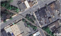
This is where the intersection of "Third and Jefferson" would be in downtown Seattle.
The view is looking straight up what would be Jefferson, but it isn't a street there - it is "City Hall Park", home to a large homeless encampment. View is looking east, up Jefferson. The King County Courthouse (far left) was opened in 1916.
.jpg")
Looking west, this is the intersection of "Third and Jefferson". That's the Morrison Hotel, which was built in 1908. On the left you will see there is more park (where presumably Jefferson Street continued down to Second Avenue.)
My best guess: "Sure-Hold" was using the Morrison Hotel as their base of operations.
Not to be outdone as far as "triangle buildings" go, Tacoma has a rather unique one down at the intersection of South 9th & Broadway, where Broadway and St. Helens converge at 9th. It was formerly the home of Gunderson Jewelers (where I opened my first charge account at age 16), but has since become a trendy coffee shop.

ADDENDUM:
RE:
@Mintgrun's archival photos of the City of Seattle posted above (post #213):
I'm going to go out on a limb here and suggest those photo images are from days prior to the "Denny Regrade", when the hills of what is now downtown Seattle were sluiced down, and the earth transported via wagons to what became "Harbor Island" at the south end of Elliott Bay. The topography today is not at all what it was in 1900.
ADDENDUM #2:
Private Lugnutz said:
I tend to avoid declarative mode without searching and re-reading and double-checking myself.
I wish I could say the same.
That empty space across from City Hall Park was puzzling me, so I went to USGS to check.
I was having trouble finding the usual 7.5 topos I would normally use, but did find a 1949 USGS map, which shows Jefferson continuing straight through between First Avenue and Fourth Avenue, so it would be more than reasonable to assume there were building(s) where that "City Hall Park" is located, as well as the flower stand immediately south of the Morrison Hotel.

1949 USGS map - Intersection of Third and Jefferson indicated with arrow.


")